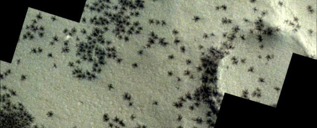
Counting whales in the ice
Monday, 11 February 2008
ECOS Magazine: Towards a Sustainable Future By Wendy Pyper

minkewhale
Aerial surveys will help with the question of Minke whale
numbers.
Source: Kevin Neff

For the first time, Australian scientists will use aircraft to count minke whales in the pack ice around Antarctica.

Since 1978 the International Whaling Commission (IWC) has been counting whales in the Southern Ocean for management and conservation purposes. Each year ships, provided by Japan, cover about one-tenth of the Southern Ocean, with each survey in the unstrengthened vessels necessarily ending at the edge of the pack ice around Antarctica. Thus, every 10 years, a circumpolar snapshot of whale abundance is obtained.

Surveys over the past two decades, however, suggest there has been a significant decline in minke whale abundance, leading to disputes over whether the decline is genuine, or an artefact caused by the survey technique.

One theory is that changes in the ice edge boundary each year, and changes in the number of minke whales present in the pack ice beyond this boundary, could be responsible for the differences in estimates of the whales in open water. In other words, could there be more minke whales hiding under the hundreds of kilometres of pack ice (and open areas within the pack ice), where the ships can’t search?

Using icebreaker ships to access the pack ice is not ideal for a number of reasons, including the whales’ responses to engine noise. In the 2007–08 Antarctic season,1 a team from the Australian Antarctic Division aim to use the Division’s two C212 fixed-wing aircraft to trial an aerial survey of the relative abundance of whales off the coastline adjacent to Casey, Australia’s closest Antarctic station, located in the Windmill Islands. The plan is to fly the planes at an altitude of about 180 m and cover at least 2500 nautical miles – flying over a mixture of pack ice and open water.

The aerial survey will be conducted at the same time as the annual ship-based survey (the Southern Ocean Whale Ecosystem Research survey), covering the pack ice region that the ship cannot access. It will be done in such a way that the data from both methods can be compared.

Information from the surveys will be used by the IWC, but will also contribute to the Australian Antarctic Division’s research (through the Australian Centre for Applied Marine Mammal Science) into minke whale distribution and abundance, and their interaction with other whale species and krill predators. The research feeds into conservation management, setting sustainable catch limits for whales and krill, and contributes to scientists’ understanding of ecosystem changes due to climate change. This first aerial survey will also test the reliability of this research technique.

Modifying aircraft for whale surveys:

The C212 aircraft have been modified for the survey in a number of ways including:

  • digital video and infrared video systems mounted under the aircraft to record everything within a strip at least 50 m on either side of the aircraft;
  • a wide-angled, still, digital camera mounted under the aircraft to record ice images at least 100 m either side of the aircraft at regular intervals; and
  • additional software incorporated to access altitude information from aircraft data logging systems, improving survey result accuracy.

As well as these modifications, the Global Positioning System will be available to accurately record whale sighting locations, and the two front and two rear observation units will be visually and audibly isolated from each other to ensure independent recording of information.

Due to the nature of the operation (including the potential for extended periods of flight over open water at low altitude), project team members have undertaken additional emergency training relating to egressing ditched aircraft, cold water hazards and life raft deployment.

1 Scientists undertaking the research will be amongst the first to fly to Antarctica on a new Airbus A319 personnel aircraft. The timing of this research will therefore depend on the weather.

This article is republished from Australian Antarctic Magazine (AAD) issue 13. 


A story provided by ECOS Magazine - Australia´s most authoritative magazine on sustainability in the environment, industry and community.  Visit ECOS to sign-up for a print subscription.
 
         Add to Google Reader or Homepage RSS Alerts           Email Alerts
CSGCT Event